Several sources have confirmed that former President Barack Obama phoned Reverend Jesse Jackson over the weekend, who is in Stable Condition at a Chicago...

There is something tender and knowing in the way Isiah Thomas speaks about the earth. It is the tenderness of a man who understands...

(Black PR Wire) SAN DIEGO — The International Coaching Federation (ICF) has recognized Cheryl Procter-Rogers, MCC, APR, Fellow PRSA, with its prestigious ICF Coaching...

People in the News

Thursday, November 20, 2025

People in the News

Thursday, November 20, 2025

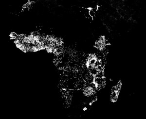
Researchers use map and light to demonstrate global poverty

Stanford researchers use machine learning to compare the nighttime lights in Africa – indicative of electricity and economic activity – with daytime satellite images of roads, urban areas, bodies of water and farmland.

One of the biggest challenges in fighting poverty is the lack of reliable information. In order to aid the poor, agencies need to map the dimensions of distressed areas and identify the absence or presence of infrastructure and services. But in many of the poorest areas of the world such information is rare.

“There are very few data sets telling us what we need to know,” said Marshall Burke, an assistant professor in Stanford’s Department of Earth System Science and an FSE Senior Fellow at the Freeman Spogli Institute. “We have surveys of a limited number of households in some countries, but that’s about it. And conducting new surveys in hard-to-reach corners of the world, such as parts of sub-Saharan Africa, can be extremely time-consuming and expensive.

See more about this story @ news.stanford.edu